


 09:27 2026-01-31
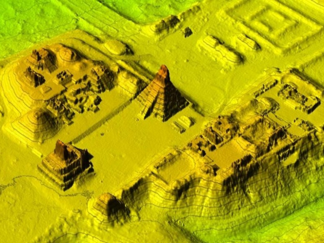
 444
444 7
7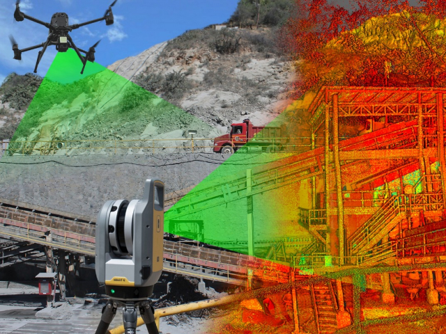
LiDAR: “digital clearing” of jungles
Laser scanning (LiDAR) is certainly a breakthrough. Flying over jungles, a drone or aircraft fires millions of laser pulses per second. Some pulses penetrate the dense canopy and reflect off the ground. How does it work? Computers remove the “noise” of trees and undergrowth, leaving an exquisitely accurate 3D map of the terrain. Under the impenetrable jungles of Guatemala, tens of thousands of houses, pyramids, and defensive earthworks were revealed — sites that no one expected to exist.
AI detective: searching for patterns
The human eye tends to miss odd irregularities in the landscape, but neural networks are trained to hunt geometry. Straight lines, perfect circles, and right angles rarely occur in nature — they are usually signs of human activity. What are the results? AI sifts satellite imagery of the entire planet, flagging suspicious objects. Hundreds of nomadic camps in the steppes and hidden villa foundations beneath British fields have been discovered — features not visible even from low altitudes.
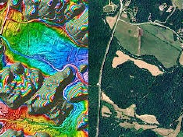
Hyperspectral vision from space
Buried ruins change the soil’s chemistry and alter how vegetation above them retains moisture. Modern satellites detect these micro‑changes in spectral bands invisible to humans. What’s the effect? Crops over ancient walls ripen slightly differently or show a different hue. From orbit, this looks like a clear “ghost” blueprint of a building emerging through a modern farm field.
Swarm reconnaissance drones
In 2026, swarms of autonomous drones are used to explore hard-to-reach caves and dense forests. They fly into narrow crevices a human cannot enter and create high-precision maps of interior spaces using ultrasound and night‑vision cameras. What was discovered? New chambers in Egyptian tombs and hidden refuges in the cliffs around the Dead Sea were found this way, preserving artifacts in near-perfect condition.
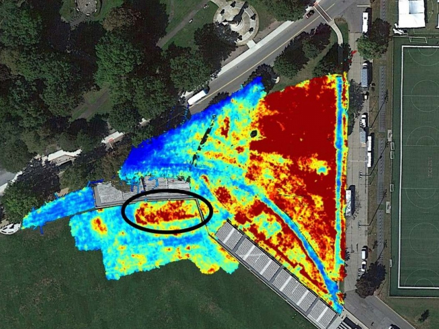
Ground-penetrating radar (GPR): X-ray for treasure hunting
Modern GPR lets archaeologists peer up to 30 meters below the surface without turning a spade. Radio waves reflect off voids, stone and metal objects. What is it used for? It finds “treasures” — rooms full of vessels or burials — with centimeter accuracy. Using new technologies, archaeologists first build a full VR model of the underground city and only then decide exactly where to make a careful trench.
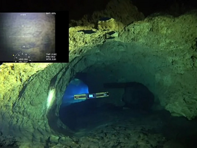
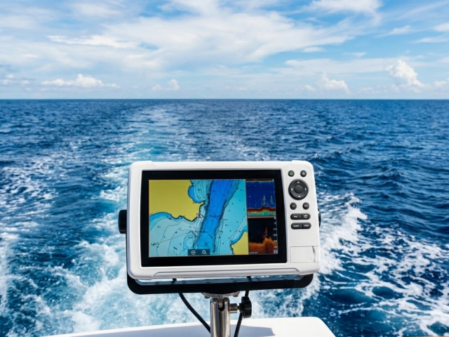
Underwater sonars: Atlantis in 4K
Marine archaeology has leapt forward thanks to autonomous underwater vehicles (AUVs). They scan the seabed with high-resolution sonar, reconstructing the layouts of sunken ports and ships. What’s the scale? Entire ancient cities lost to earthquakes (like Heracleion) can now be studied in detail without leaving the boat, using photogrammetry that stitches thousands of images into a single 3D model.
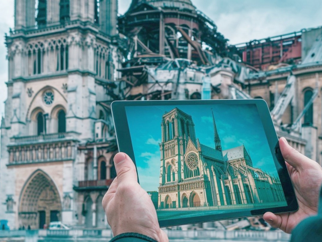
VR reconstruction: past brought to life
Recovered data is immediately loaded into game engines. This lets you do more than look at stones — you can “walk” through a reconstructed city in augmented reality. What’s the intrigue? Modern tourists can put on goggles right at a dig and see temple walls rise around them in their original splendor. This is a bridge between the dry data of cyber‑archaeologists and the living imagination of people.


-
Grand Choice
Contest by
InstaForexInstaForex always strives to help you
fulfill your biggest dreams.JOIN CONTEST -
Chancy DepositDeposit your account with $3,000 and get $8000 more!
In March we raffle $8000 within the Chancy Deposit campaign!
Get a chance to win by depositing $3,000 to a trading account. Having fulfilled this condition, you become a campaign participant.JOIN CONTEST -
Trade Wise, Win DeviceTop up your account with at least $500, sign up for the contest, and get a chance to win mobile devices.JOIN CONTEST


